 |
||||||
|
|
|
|||||
 |
||||||
| |
|
|
|
|
|
|
|
|
||||||||||||||||||||||||||
|
|
|
|||||||||||||||||||||||||
|
|
|
|
|
|||||||||||||||||||||||
 |
|
|
||||||||||||||||||||||||
| IVS was founded in 1995 to provide interactive 3D visualization and analysis software and services for the ocean mapping industry. The primary product is the Fledermaus software suite, an interactive 3D visualization and analysis software that originated from research at the Ocean Mapping Group (OMG) at the University of New Brunswick. IVS benefited from the association with the world-leading OMG in shaping the early development of the software from a very powerful visualization application to a fully featured analysis and processing suite of software. Since the company's inception in 1995, the Fledermaus software has established itself as the industry leading software for 3D visualization of marine information and associated attributes, specializing in extremely large data sets. The software has been used extensively across the ocean industry in geological surveys, hydrographic surveys, mine clearance and beach landing surveys; and a variety of geo-hazard surveys in support of offshore engineering projects worldwide. 2001 marked a significant year for IVS when the Fledermaus software was used on projects in the waters of every continent. The software now sets the standard in interactive 3D visualization for the ocean mapping industry in all sectors - nautical charting, marine geological survey and geo-hazard surveys in the offshore oil and gas industry. |
|
|||||||||||||||||||||||||
|
|
||||||||||||||||||||||||||
|
|
|||||||||||||||||||||||||
|
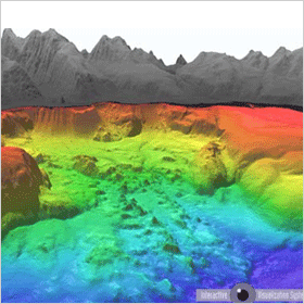
Fledermaus Standard is a powerful interactive 3D data visualization system that is used for a variety of applications including environmental impact assessment, mining, geology, and research.
Innovative data exploration features including the ShiftScapeTM rendering engine and the Bat (3D input device), allow for intuitive 3D exploration of geo-spatial data. A wide variety of industry standard formats are supported for direct import of data to the 3D scene. Object types such as digital terrain maps, point clouds, lines, polygons, satellite imagery, etc. can all be loaded and analyzed in a single scene. Due to its flexible object oriented software design, Fledermaus can be easily tailored to support many additional visualization modules. If you would like more information on Fledermaus, the full documentation is available online. A free viewer for Fledermaus files named iView3D is also available. |
||||||||||||||||||||||||||
|
||||||||||||||||||||||||||
|
|
|||||||||||||||||||||||||
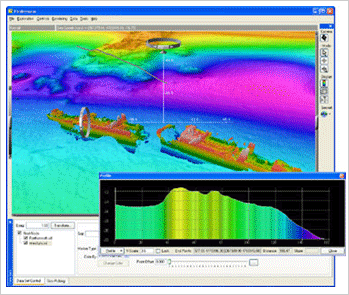
| Fledermaus Professional is a powerful 3D data visualization system that uses the same core technologies as Fledermaus Standard, plus adds a sophisticated Area Based Editing module, cable and route planning, and real-time tracking of objects. Fledermaus Professional is used in a variety of applications such as swath bathymetry editing and quality control, marine construction, military applications, and coastal zone mapping. Featuring the same intuitive data display as Fledermaus Standard, Fledermaus Professional is capable of visualizing large volumes of data of numerous types in a single 3D scene with the powerful ShiftScapeTM rendering engine. Data display can be controlled with the Bat, an intuitive 6 degree of freedom input device. A wide variety of industry standard formats are supported for direct import of data to the 3D scene, and Fledermaus also allows data from remotely operated vehicles, ships or other entities, to be visualized in real-time. Due to its flexible object oriented software design, Fledermaus can be easily tailored to support many additional visualization modules. If you would like more information on Fledermaus, the full documentation is available online. A free viewer for Fledermaus files named iView3D is also available. |
||||||||||||||||||||||||||
|
||||||||||||||||||||||||||
|
|
||||
|
Dragon
& Elephant Enterprises Co., Fl. 12-4, No. 251 Ming-Chun 1st. Road Kaohsiung, Taiwan ROC Tel: +886 – 72272887 Email: sales@dragon-sat-phone.com.tw
|
||||
|
|
|
|
|
|